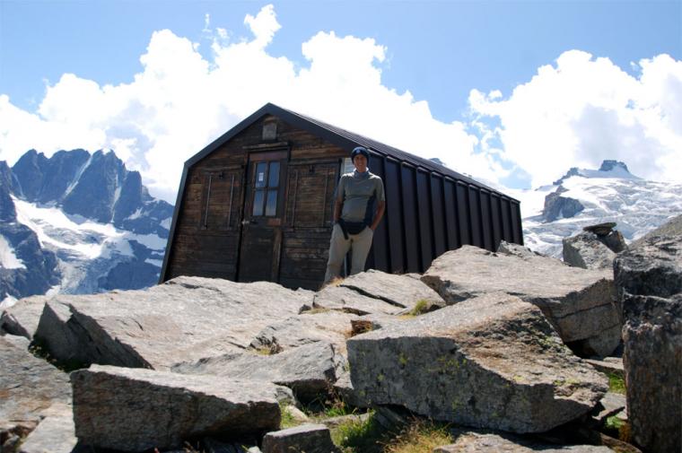
Leonessa Bivouac, from Valnontey

Edited by:
Maurizio Bergamini
Updated at: 07/04/2026
Access
Leaving the motorway at the Aosta Ovest exit, turn right and take the Valle di Cogne. Drive through the village of Aymavilles and after 1.3 kilometres at a roundabout take the second exit. Go up the regional road for 19 kilometres passing through the villages of Vieyes, Epinel and Crétaz until you reach a roundabout: take the first exit onto Avenue G.F Cavagnet, to be followed for about 350m. Inside the village of Cogne turn right taking the small road that after about 2.7km reaches the village of Valnontey anticipated by the large car park on the right of the road.
[0h33'] - [23.3km]
* How to get there with GMAPS
* How to get there with Apple Maps
The information provided here has been verified at the date of the survey of the itinerary. Before setting off, you should make sure that no substantial changes have occurred on the route to the starting point. We therefore recommend the use of the satellite navigation apps provided by Google or Apple for up-to-date and detailed directions.
Introduction
Combined excursion with mountain biking (not essential) plus trekking. The destination is a bivouac located in the Herbetet valley, at the base of the mountain of the same name (m 3778) and the pass of the same name (m 3263) leading to Valsavarenche rejoining the Alta Via route no. 2. This is an extremely scenic spot on the Gran Paradiso glaciers and from where it is possible to 'binocularly' see the wildlife of the National Park. The characteristics of the route make it suitable for people in good physical-athletic condition.
Description
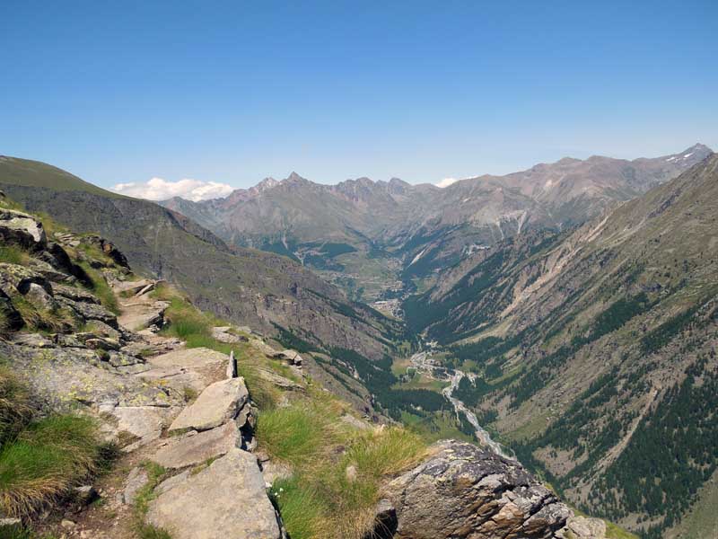
Leave the car in the forecourt of Valnontey (1666 m, ), just above the village of Cogne (Aosta West motorway + 25 km approx.) and put on your bicycles, set off along the dirt road that runs alongside the stream on the orographic right. It will take about twenty minutes to reach a fork in the road, which points towards the river bed, where the structures of a bridge are evident, over which the cross-country skiing track passes near its extreme point in winter.
Having left your bicycles properly padlocked and hidden from view, you will ascend the path, which becomes narrower but not at all steep. (Experienced bikers can continue further up to the crossing of the stream, but the little road often narrows and the possible crowding in July and August leads us to advise against this choice, out of respect for the safety and security of all).
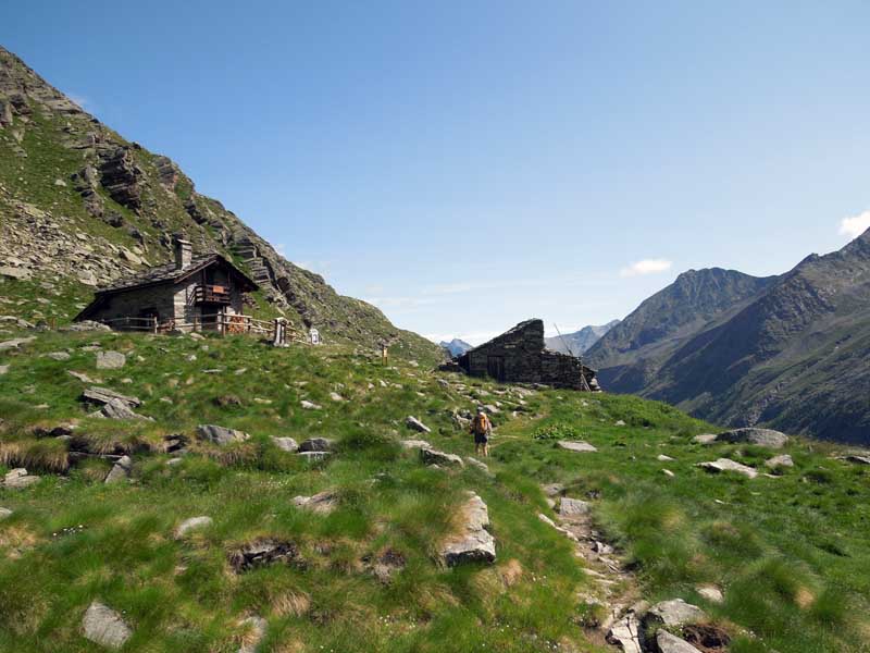
Following the signpost Trail N° 22G we cross the stream over a bridge. We continue with ease to the fork that separates the trails Trail N° 22 and Trail N° 22G from the others. Now the slope becomes very steep, but the track draws wide hairpin bends, widely spaced, thus gaining height through a considerable lengthening of the distance to be covered. In 2h30' - 3h00' you reach the gamekeeper's house in the locality of (needless to say) Herbetetet (2435 m), where it crosses the path coming from the Sella refuge. There is also a pleasant fountain here.
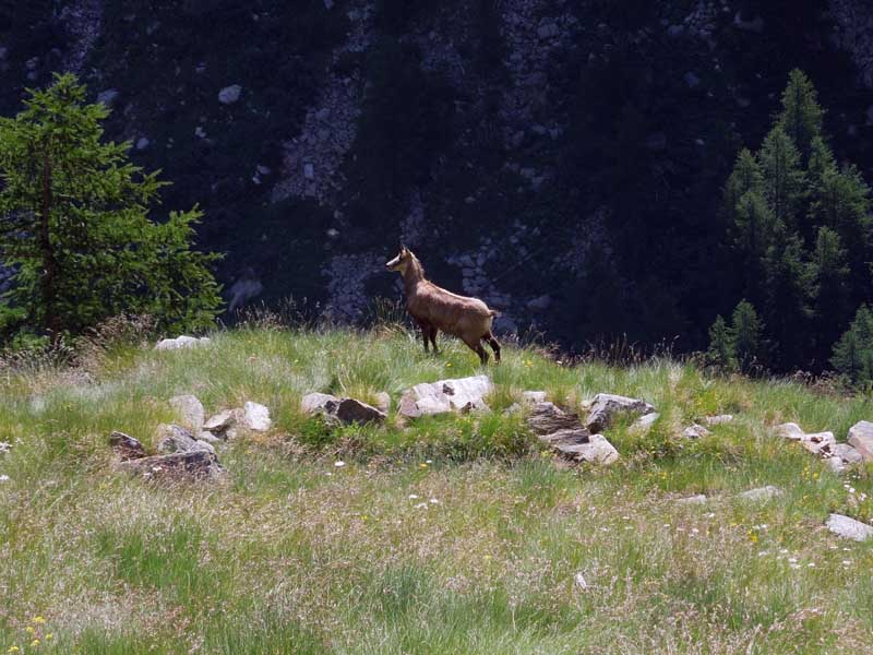
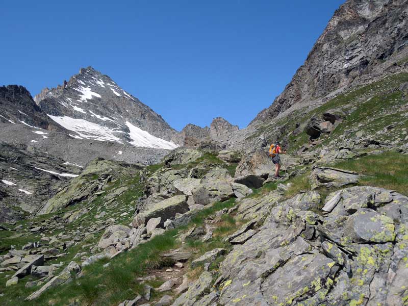
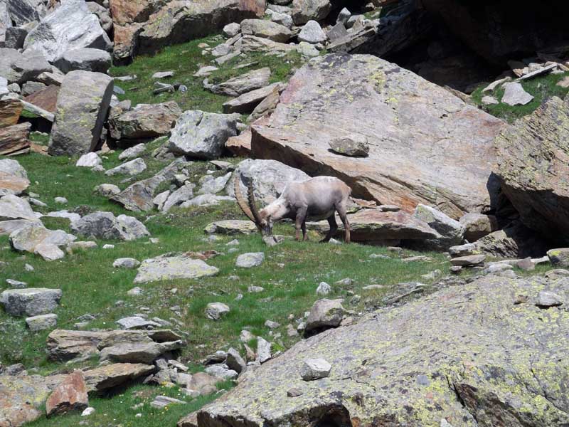
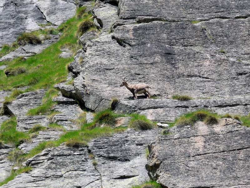
The path continues along a very steep slope, with the usual wide hairpin bends. Leaving the gamekeeper's house a good distance away, it is advisable to carefully scrutinise the ridge to the right of those ascending, where chamois and ibexes graze.
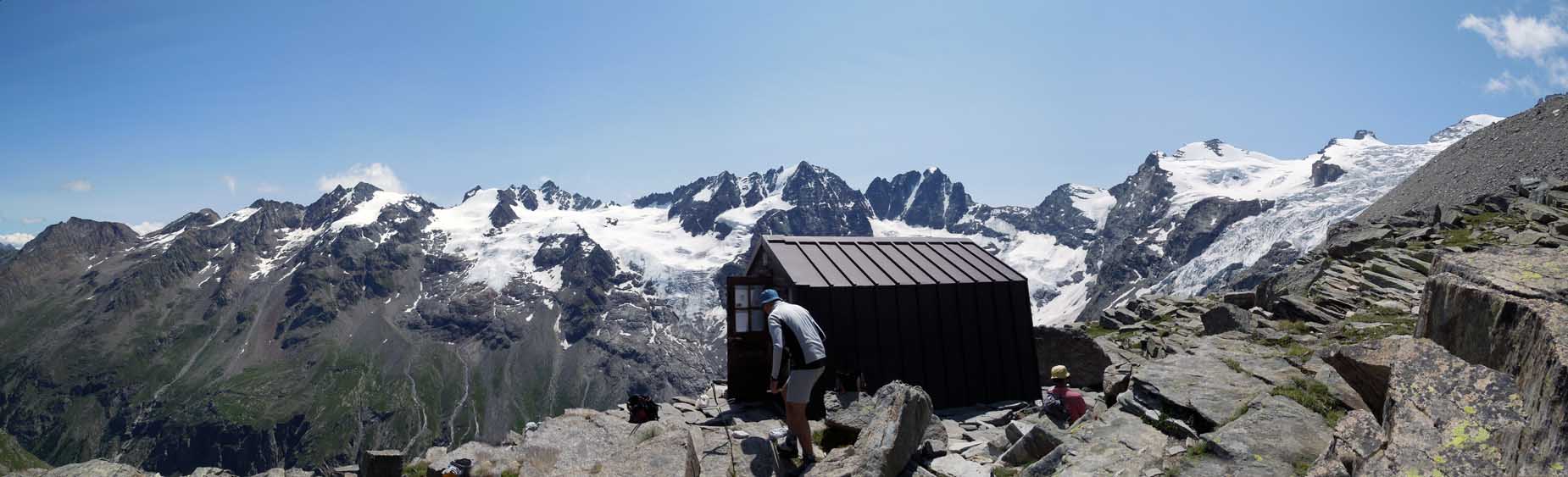
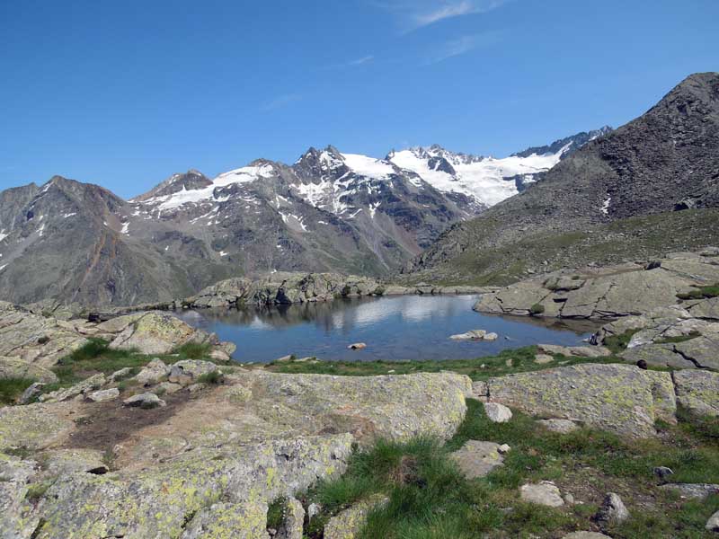
The path remains evident until the fork for the bivouac, well signposted in yellow paint Sentiero N° 22G. Then continue left into a scree slope, paying attention to the yellow markings and stone cairns. We soon reach our destination: a wooden hut, rather spartan, with 12 beds and two tables with benches; a handwritten sign warns us not to leave our rucksacks outside during the night, as foxes would think to empty them of provisions!
Ascent time: 4h00' - 4h30' (including the bike section) Descent time: 2h40' (including the bike section) Trail sign: Trail N° 22G Characteristics: Naturalistic Difficulty: Good Easy Walkers (BCF) Recommended period July, August, September Altitude of the starting point: 1666 m Difference in altitude: Ascent 1224 m Altitude of the arrival point: 2910 m Access to the starting point: Water Exit: Aosta West -> Cogne -> Valnontey Introduction Combined trip with mountain bike (not essential) plus trekking. The destination is a bivouac located in the Herbetet valley, at the base of the mountain of the same name (m 3778) and the pass of the same name (m 3263) that leads to Valsavarenche, rejoining the Alta Via route no. 2. This is an extremely panoramic spot on the Gran Paradiso glaciers and from where it is possible to 'binocularly' see the wildlife of the National Park. The characteristics of the route make it suitable for people in good physical-athletic condition. Description Leaving the car in the forecourt of Valnontey (1666 m, ), just above the village of Cogne (Aosta West motorway + approx. 25 km) and mounting the bicycles, set off along the dirt road that runs alongside the stream on the orographic right. It will take about twenty minutes to reach a fork in the road that points towards the river bed, where the structures of a bridge, over which the cross-country skiing track passes near its extreme point in winter, are evident. Having abandoned the bicycles, duly padlocked and hidden from view, we ascend the path, which becomes narrower but not at all steep. (Experienced bikers can continue further up to the crossing of the stream, but the little road often narrows and the possible crowding in July and August leads us to advise against this choice, in deference to the safety and security of all). Following the trail marker Sentiero N° 22G we cross the stream over a bridge. We continue with ease to the fork which separates Sentiero N° 22 and Sentiero N° 22G from the others. Now the slope becomes very steep, but the track draws wide hairpin bends, widely spaced, thus gaining height through a considerable lengthening of the distance to be covered. In 2h30' - 3h00' you reach the gamekeeper's house in the locality of (needless to say) Herbetetet (2435 m), where it crosses the path coming from the Sella refuge. There is also a pleasant fountain here. The path continues along a very steep slope, with the usual wide hairpin bends. Leaving the gamekeeper's house at a good distance, it is advisable to carefully scrutinise the ridge to the right of those ascending, where chamois and ibex graze. The path remains evident until the fork to the bivouac, which is well marked in yellow paint on Path No. 22G. Then continue left into a scree slope, paying attention to the yellow markings and stone cairns. We soon reach our destination: a wooden hut, rather spartan, with 12 beds and two tables with benches; a handwritten sign warns us not to leave our rucksacks outside during the night, as the foxes would think to empty them of provisions!
Rise time: 4h00' - 4h30' (incl. bike ride)
Descent time: 2h40' (incl. bike ride)
Trail signposting sequence: Trail no. 22G
Features: Naturalistic
Recommended period: July, August, September
Top of departure point: 1666 m
Descent level: Ascent 1224 m
Top of arrival point: 2910 m
We have been there

Edited by:
Giancarlo Beretta
Bivacco Leonessa, traversata al rif. Sella
Sempre bella la salita a questo bivacco con il valore aggiunto della traversata al rifugio Sella. Facile ma lunga, con solo qualche breve tratto esposto, questa escursione offre bellissimi panorami sui ghiacciai e le vette della Valnontey. Avvistato numerosi camosci e stambecchi e un paio di scoiattoli. Poca gente al bivacco mentre la traversata era affollata. In compagnia di Stefania. Avvistamenti faunistici: Capra ibex, Rupicapra rupicapra, Sciurus vulgarisSempre bella la salita a questo bivacco con il valore aggiunto della traversata al rifugio Sella. Facile ma lunga, con solo qualche breve tratto esposto, questa escursione offre bellissimi panorami sui ghiacciai e le vette della Valnontey. Avvistato numerosi camosci e stambecchi e un paio di scoiattoli. Poca gente al bivacco mentre la traversata era affollata. In compagnia di Stefania. Avvistamenti faunistici: Capra ibex, Rupicapra rupicapra, Sciurus vulgaris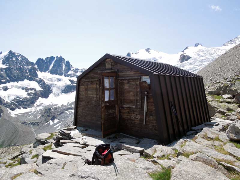

Edited by:
Massimo Martini
Bivacco Leonessa
Terza meta di giornata! Arrivo al Bivacco dopo la traversata dei Casolari dell'Herbetet: posto bellissimo!!! Terza meta di giornata! Arrivo al Bivacco dopo la traversata dei Casolari dell'Herbetet: posto bellissimo!!!