SS 36 Milano-Colico, exit Annone/Oggiono/Galbiate. Take SP 49 for 1.5 km, then turn left onto SS 639 for Erba. Turn right onto Via Martinelli (SP 42) and follow the signs for Canzo. At the centre of the village, follow signs to the right for Gajum. At the end of the road, park in the square on the left. Attention: the area is very busy on Sundays, so take this into account to avoid parking problems. Other possibilities for approaching the ferrata: from Valbrona (Co) and from Valmadrera.
.
Introduction
The Ferrata del Venticinquennale is one of the classics of the Larian Pre-Alps. In the area of the Larian Triangle, in fact, there is a concentration of various hiking, climbing and ferrata routes of considerable difficulty.
The one described here was set up by the Canzo CAI in 1972 and restructured with considerable changes in 2007.
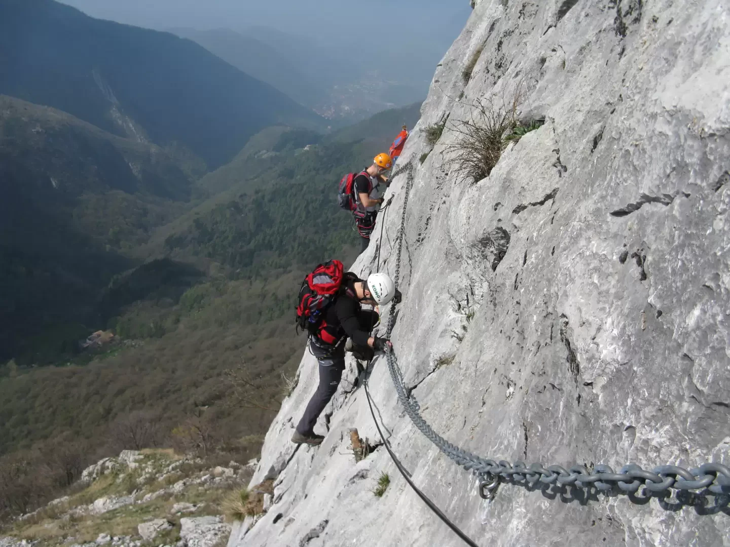
The route runs along the western and southern slopes of the Corno Occidentale di Canzo and is equipped along its entire length with a chain and, only after the first section, with a safety cable. This entails some difficulty, in the first part, which is also the most demanding, in sliding the carabiners.
Otherwise, the route is very beautiful, severe and very scenic.
The 250 m of altitude difference can be overcome in just over an hour.
Description
Approach
From the forecourt, following the signs for path , take the lovely cobbled road on the left which leads, with a moderate, steady climb, to the Terz Alpe hut. When you reach it, still following the numerous signs, turn left and climb up a steep path, still marked no. 1, which in about 45 minutes leads to the start of a scree slope. Cross it on the right, heading towards the west pillar of the Corno Occidentale di Canzo, from which the plaque and the ferrata start are clearly visible. A very advisable alternative is to follow the road as far as the first sign on the left of path no. 1 "Ripianino Corni" located shortly after the ruins of Second'Alpe. A small path climbs up through the forest without excessive strains and joins the one coming from the Terz'Alpe hut just below the signs for the via ferrata. This variant avoids excessive leg fatigue in view of the greater effort to be made.
The via ferrata
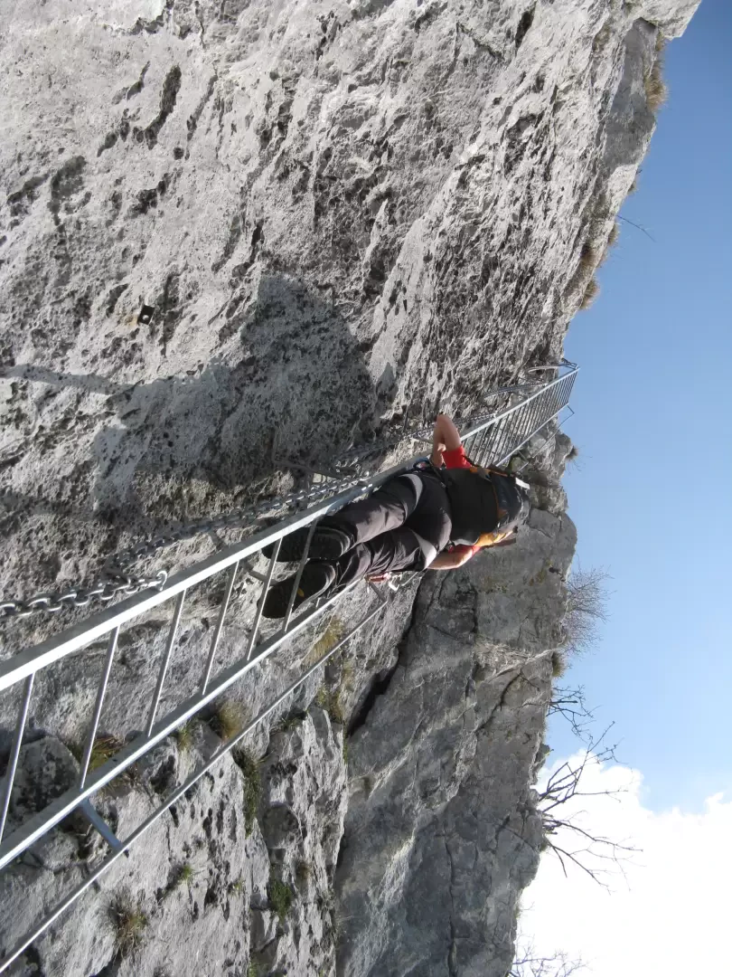
After a short route to the right, the route climbs diagonally to the left, taking you close to a vertical slab with some artificial support and an iron stirrup, already present in the old layout. This passage is probably the most difficult of the entire route. An amusing gully-dihedral follows, leading to the base of the south face. Up to this point the route is equipped with only the chain. You now come to a crack that is overcome with some artificial aid and a first traverse that ends with a jump, also facilitated by stirrups. A second ascending traverse ends with a smooth but fairly sloping slab which precedes a small but tiring overhang. We now come to the start of a long, fairly demanding traverse, at times tiring for the arms, which should be tackled with due caution but without hesitating too much. Often the support ledge disappears, but the wall holds the grip of the soles well. The traverse is interspersed with a few vertical and exposed jumps, facilitated by stirrups. A last vertical slab leads to a path of rocks that leads to a ladder, from which one exits by climbing a second equipped path. The final pillar remains to be tackled, consisting of vertical slabs, often overhanging, served by stirrups. It is necessary to overcome the last overhang, short but infamous for the difficulty of sliding the carabiners, to finally gain the anticima of the Corno Occidentale. From here, a track, marked by marks on the rocks, leads to a notch (Passo della Vacca) which must be overcome on the descent and which, although not difficult, is exposed and must be approached with caution. Once back on the path, you will soon reach the summit cross (1373 m). For the descent, follow the red marks that lead northwards towards a steep gully from which you access a second gully at the end of which a path leads to the Pianezzo meadows and the SEV Refuge.
Ferrata interessante, bella e severa. Il primo tratto è reso ostico più per la difficoltà di far scorrere i moschettoni sulla catena che non dall'impegno fisico necessario a superarlo.
Il traverso è piuttosto aereo, bello e con qualche tratto piccante.
Da fare possibilmente non di domenica.Ferrata interessante, bella e severa. Il primo tratto è reso ostico più per la difficoltà di far scorrere i moschettoni sulla catena che non dall'impegno fisico necessario a superarlo.
Il traverso è piuttosto aereo, bello e con qualche tratto piccante.
Da fare possibilmente non di domenica.


Comments (0)
Sign in to leave a comment