The Biancane Loop, from Lagoni

Edited by:
Massimo Martini
Updated at: 16/07/2026
Access
Road directions
From the junction with the in Follonica, head north-east. At the first roundabout (1.9 km), take the first exit and stay on the . At the second roundabout (3.1 km), take the second exit and continue on the . Continue for a further 9.0 km and, at the third roundabout (12.1 km), take the second exit onto the . At the fourth roundabout (18.9 km), take the second exit and stay on the for a further 11.6 km. At the fifth roundabout (30.5 km), take the second exit, then turn left immediately onto the towards Monterotondo Marittimo. After 3.2 km, turn right onto Viale Giacomo Matteotti/ (33.7 km in total) and, 190 m further on, turn right onto Via dei Lagoni Boraciferi (33.9 km). Continue for 200m to the car park in Piazza Francesco de Larderel in Lagoni (34.1km).
Car park
The free car park 🅿️ in Piazza Francesco de Larderel is located in the village of Lagoni (Via dei Lagoni Boraciferi, 58025 Lagoni GR), near Lagone Cerchiaio and the entrance to the Parco delle Biancane.
Access by public transport
To reach the Parco delle Biancane, you will need a private vehicle.
Distance and journey time
🕒 Journey time: 34 minutes (from Follonica)
📏 Distance: 34.1 km (from Follonica)
GPS navigation
Important information
The directions provided were verified on the date the route was mapped. Before setting off, we recommend checking for any changes to the route or road conditions. For up-to-date information, please consult Google Maps or Apple Maps.
Introduction
A circular walk in the Parco delle Biancane, a geothermal area in the municipality of Monterotondo Marittimo (Grosseto), in Tuscany. The route is divided into two adjoining sections — the southern area and the northern area — starting near Lagone Cerchiaio, along the road linking the town to the village of Lagoni.
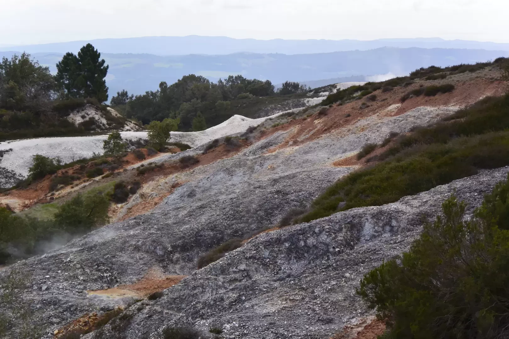
The route passes through an area where pressurised geothermal fluids reach the surface in various forms: fumaroles (jets of steam rising from dry ground, with temperatures of up to 115°C), bulicame (muddy depressions that bubble continuously due to endogenous gases), putizze (emissions of hydrogen sulphide), mofettes (emissions of carbon dioxide, which are dangerous in enclosed depressions) and lagoni (basins collecting geothermal water). In the northern area, the route reaches the old jasper quarry, where the siliceous rocks display a white colouration caused by geothermal leaching, which has removed the iron oxides responsible for the usual reddish pigmentation. Along the route, the remains of the industrial boric acid mining activity, which began in the early 19th century, are visible.
The route is signposted and marked out with safety ropes in the sections adjacent to active areas. It presents no technical difficulties and is accessible to walkers of all abilities.
Description
0h00' 0.00km Near Lagone Cerchiaio (528 m), take the tarmac road uphill, following the signs for the MUBIA Geomuseum. Steam can be seen escaping from the retaining wall to the right of the road; greyish-white crystalline efflorescences of gypsum and sulphates are deposited on the limestone blocks of the wall, produced by the reaction of calcium carbonate with hydrogen sulphide vapours. On the left-hand side of the road are the old wash houses, built from octagonal bricks.
0h15' 0.32km Once you reach the forecourt of the MUBIA Geomuseum (572m), walk past the museum building and the adjacent district heating plant, then take the road leading uphill on the left-hand side.
0h25' 0.53km Reach the upper forecourt (617m), from which the park's footpath begins. From the square, you can see the geothermal well installations that convey steam to the power station at Monterotondo Marittimo: valves, wellheads and steam pipes. From the far end of the square, take the flight of steps leading down to the southern area. After a few dozen metres, you will reach a terraced area where the water from the Chiorba spring 💧 flows through a channel made of overlapping roof tiles; the spring emerges from a tunnel about 10m further upstream with an outlet temperature of around 50°C. Continue uphill through the area of greatest geothermal activity, following the route marked out by safety ropes.
0h45' 1.10km Reach the terrace of the park’s main lagoon (613m), situated within a truncated-conical crater-shaped depression several metres in diameter and approximately 5m deep. The muddy water bubbles continuously due to endogenous gases; emissions more intense than usual may eject boiling mud into the areas near the rim. Continue uphill past the lagoon to the dirt track that separates the southern area from the northern area. Turn right and, after a few dozen metres, follow the short path downhill towards the first viewpoint, from which you can see the Tyrrhenian coast stretching from Baratti to Punta Ala and the Argentario, with the island ofElba in the foreground. Climb back up to the clearing by the old jasper quarry.
1h10' 1.55km From the clearing at the jasper quarry (695m), where the quarry faces and the layout of the site roads are still visible, take the circular path that runs around the perimeter of the northern area. Along the route, you will encounter extensive outcrops of leached jasper — siliceous rocks bleached by geothermal leaching that has removed the original iron oxides — alternating with ochre-coloured zones and scattered deposits of bright yellow native sulphur crystals. The path passes two further vantage points equipped with benches. At the end of the northern loop, the trail descends and concludes the route at Lagone Cerchiaio (528m) 2h05' 3.05km (200 m elevation gain) (200 m elevation loss)
Visitor information
The Biancane Park is always open to the public. The main car park is situated near the village of Lagoni Boraciferi and the Pump Track area (Piazza Francesco de Larderel).
The MUBIA Geomuseum, housed in the former ENEL power station 0.32 km from the trail’s starting point, is open from 1 June to 13 September, Tuesday to Sunday, 10.00–13.00 and 15.00–18.00; it is closed on Mondays (please check with the contact details for any special opening days). Ticket office: full price €7; reduced price €5 for groups of more than 15 people, residents of the municipality of Monterotondo Marittimo and school groups of all levels; free for children under 11, for disabled visitors with a carer, for guides accompanying groups and for teachers with their classes. Audio guides and 3D viewers are available for €5 each, in addition to the admission ticket. Contact details: tel. +39 335 101 7368, portadelparco@comune.monterotondomarittimo.gr.it.
Special packages are available for school groups: a guided tour of the museum, lasting 1 hour, maximum 25 participants, €60 per group; a guided trek in the Biancane Park, lasting 2 hours, maximum 20–30 participants, €150 per group.
In areas adjacent to the geothermal zones, do not go beyond the safety ropes: the geysers reach temperatures of 115°C and mud can be ejected from the lagoons without warning. Mofettes are dangerous in enclosed depressions; follow the park’s signage carefully.
Comments (0)
Sign in to leave a comment