From the motorway exit take the SR in the direction of Cogne as far as the hamlet of Crétaz; here it is best to continue by car in the direction of Cogne, until you find the small road on the right that goes back towards Crétaz (1480 m) but further down near the stream. At the end you reach a clearing where you can park comfortably.
Introduction
From the wooded heart of the Gran Paradiso National Park, in an environment rich in alpine flora and fauna, crossing two of the most characteristic and wildest valleys in the Val di Cogne, to finally reach one of the highest glacial areas in the entire valley: one of the very rare glaciers 'surviving' outside the great north faces, enclosed and protected by the circle that goes from the Grivola, to the Punte Bianca, Nera and Rossa, and the Grivoletta.
Description
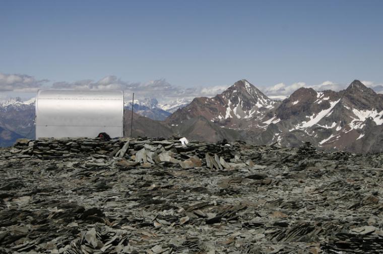
In front of the bridge we find the signposts of all the paths: we cross it, taking a steep path that climbs the grassy slope and soon approaches the forest. Here the path bends to the right (ignoring a track that leads to the left) and with a first diagonal begins the series of twists and turns that lead us, still to the right, to the crossing, on a bridge, of a stream that descends into the woods and whose banks, towards the upper part, are often populated by groups of chamois We continue in this way, often up a steep slope, skirting and reaching some pleasant grassy open spaces where we find several characteristic cottages, some very picturesque, others almost completely ruined. With a final climb, we reach the clearing where the lower Les Ors huts stand, abandoned and often used by chamois as winter and night shelter. From here we already have a full view of the two peaks that guard, like grim sentinels, the entire Les Ors basin: l'Herban and l'Ouille. In a matter of minutes, we then come out of the beautiful larch forest that we have climbed so far, reaching the cross that characterises the Les Ors damon huts (2030m; 1h30'). A brief pause to admire the beautiful grassy plateau that opens up before us, with its cosy atmosphere, closed in on the left by the rocky west face of the Ouille, is a must. The site is populated by numerous families of marmots, quite willing to let themselves be photographed (and in late spring, also by several "local" groups of well-fed ibex). We continue slightly uphill to the right to meet the lower part of the second forest, which descends from the dividing ridge separating us from the Pousset valley. After a long diagonal on the flank of the Les Ors clearing, the path begins to climb again and we soon reach the junction for the Vallone di Vermiana. We continue to the right towards the Pousset PNGP hut, which we reach in a few minutes (2285m) located right on the watershed ridge, in an excellent panoramic position: in front of us, the east face of the Punta Pousset, with its long and jagged north-east ridge, is clearly visible. We begin a slight descent on the diagonal that descends to touch the bottom of the Pousset valley, fording a few small streams, and then resuming the ascent with wide bends on open ground, in a very impressive natural environment. A short incline precedes the arrival at the characteristic cross that marks the old agglomeration of huts in the upper Pousset, completely disused (1529m, 3h00') in the low season, a favourite haunt of large groups of ibex. This is where the real steep part of the itinerary begins, in an increasingly wilder environment where the pastures of the upper Pousset gradually give way to increasingly detrital and rocky terrain as you approach the spurs of the Pousset. After a certain distance, we come to a fork with the path to the right, which heads towards the summit of the aforementioned point; we instead proceed to the left, climbing steeply upwards and then skirting a slope of boulders that descends downwards, until we reach the rocky outcrops that descend from the Col Pousset - Punta Pousset ridge. From here, after a short stretch where the path is a bit landslide-prone and exposed (be careful on the way back), we advance halfway up the slope in a southerly direction, crossing some scree fals plains that are always well signposted, until we find ourselves exactly under the last 'ramp' that separates us from the col: a gigantic scree slope that we climb up at the easiest points, accompanied by the numerous yellow "arrows", until we finally come out near the Bivouac, (3198m, 4h30') at the edge of the basin of the underlying Trajo Glacier: in front, on the opposite side of the glacier is the wild east face of the Grivola and the less imposing, but similar, Grivoletta, separated by the Clochettes pass where the Balzola Bivouac (alpine) is located. Running northwards from the col, you can link up with the traverse to the Rifugio Sella, skirting the slopes of the Punta Rossa to the col of the same name, and then descend into the Lauson valley.
.
Share
We have been there
Edited by:
Inuk
Monday 17 August 2009
Bivacco Gratton
Bellissima gita con un dislivello importante. Panorama eccezionale e ambiente superbo. Abbiamo impiegato 4h30 con circa un'ora di sosta. La discesa è ra/ri-pidissima.
Da consigliare!!Bellissima gita con un dislivello importante. Panorama eccezionale e ambiente superbo. Abbiamo impiegato 4h30 con circa un'ora di sosta. La discesa è ra/ri-pidissima.
Da consigliare!!


Comments (0)
Sign in to leave a comment