Freo Mountain Hut, from Passo Croce
Edited by:
Maurizio Loconti
Updated at: 05/09/2026
Access
Take the Versilia exit on the A12 motorway and follow the signs for Serravezza. Once you have passed through the village, continue towards Castelnuovo di Garfagnana. Drive uphill for a few kilometres along a narrow road (watch out for cyclists!). Pass the junctions for Levigliani and Terrinca (which you should ignore), and after the sign marking km 9 on the SP10 (about 21 km from the toll booth), turn right onto a (wider) road that climbs for 6 km to Passo Croce (1,160 m), where you can park.
Introduction
A circular walk from Passo Croce, at the foot of Pania della Croce in the Apuan Alps.
Description
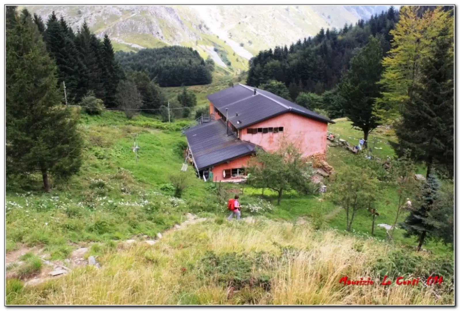
At the start, there are no signs or markings, and there’s a fork in the road straight away. Fortunately, we’d done our research properly and knew we had to turn left onto the flat section, whilst the right-hand path leads uphill to a quarry. It’s a wide dirt track which, further on, becomes tarmacked again for a stretch. At one point, due to a small stream running underneath, the road is collapsing (fortunately?!). In fact, there’s a nuisance of constant traffic... The route is mostly shaded, but there’s no shortage of panoramic views to the left of the various peaks of the Apuan Alps. On this stretch, there’s NOT a single signpost to be found, but carry on until a path joins from the left. (25’). Finally, there is a vertical signpost indicating the various destinations. The route then follows the western slopes of the Torrioni del Corchia and leads to the Fociomboli pass (1,260 metres – 10’ – a few parked cars), the watershed between the coastal and inland sides of the Apuan Alps. Here there is a major junction of paths; turn right and head uphill towards the Retro Corchia quarries (the return route is to the left). In a few minutes (8') you’ll come to another fork where you enter a dense woodland (left). In about a dozen minutes, you pass a ruin… There are several significant ups and downs as you make your way through a dense beech forest along the north-eastern slopes of Monte Corchia. As the path descends (at times steeply), the vegetation becomes sparser, and you can make out, to the left amidst the clouds, the summit of Pania (the best-known and most popular peak in the Apuan Alps, even amongst hikers) and, to the right, Corchia. You can also see hikers coming down from Corchia itself. Further down, after a short stretch through a pine forest, you emerge just above the Rifugio Del Freo 65’ (1,180 metres – approx. 250 metres elevation gain and 2 hours one way). For a moment, Pania almost breaks free from the clouds… whilst a spider weaves its web from the refuge’s window…
The refuge is set in a typical mountain setting and is spread over two floors. The sleeping area has around fifty beds in small rooms and dormitories. Downstairs is the kitchen (serving simple, traditional fare!) and the communal area with dining rooms
(Refuge telephone: 0584-778007 - www.rifugiodelfreo.it - info@rifugiodelfreo.it).
After a break, head downhill and, immediately at a fork, keep left on level ground (there’s a spring straight away – 5’). You enter a beech wood once more and, after 15’, a charming sign invites you to help carry firewood to the refuge... You pass close to the Tana dell’Omo Selvatico, 1,170 m, a sinkhole only for the most experienced and well-equipped (the cave, into which a small stream disappears, reaches a depth of almost 300 metres with tunnels and shafts, for speleologists only). You walk for a long time, losing a little altitude, along the mountainside above the Canale delle Verghe and then pass by old, completely abandoned ruins (Raspagiana and Gualdana di Sopra)... the mule track, offering a pleasant walk along the hillside, winds its way through beautiful beech trees with their tangled roots… The woodland is no longer maintained and you’ll come across more than one tree felled by the winter… in 50’ you reach a major junction where you turn left. Suddenly, you emerge in front of the Oratory of the Holy Trinity (980 m – 15'), which has been restored but is sealed up like a bank... Now the view opens out onto the wide green plateau of Puntato, once a summer mountain pasture with fields cultivated with rye and potatoes. Several houses are mere ruins, whilst others have been restored. As along the entire route, you’ll notice several small chapels (known locally as ‘Marginette’ – sacred shrines situated at the roadside which, in the past, provided places for travellers to rest and pray), which are usually well maintained. Further on, the woodland returns and the route continues steadily uphill… You must pay close attention to the signposts, ignoring – on two occasions – right-hand turnings (which is not entirely straightforward) that lead downhill or along level ground. Take care when fording the stream that flows down from the Fociomboli peat bog above, where you finally arrive (1,130 m – 40’). It is an important wetland in the Apuan Alps: a grassy basin (the remnant of a small lake in a glacial cirque) which preserves rare plants, silt deposits, peat in the subsoil and fossilised pollen that bear witness to the climatic and floristic history of past eras (an information board provides a detailed account). A final steep climb (signposted shortcuts) leads back to the Fociomboli pass (25') where, following the morning’s route, you return to the car in 30' (280 metres elevation gain and 3 hours return).
In summary: difficulty E (not all junctions are clearly signposted), 530 metres elevation gain with ups and downs, total round trip 5 hours; weather sometimes cloudy, but fair, and a bit warm
On the way back, we took a different route via the quarries above Massa...
Filled up with petrol in Massa… only 1.677 E.!
Always cheaper than in Genoa…
if you’d like to see some photos, they’re at the link
http://www.cralgalliera.altervista.org/altre2014.htm at the corresponding link
http://cralgalliera.altervista.org/RifugioDelFreoApuane.pdf
Comments (0)
Sign in to leave a comment